


107
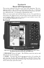
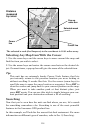
The arrow in the center of the screen is your present position. It points
in the direction you're traveling. The magenta line extending from the
back of the arrow is your plot trail, or path you've taken.
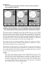
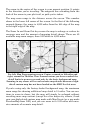
The map zoom range is the distance across the screen. This number
shows in the lower left corner of the screen. In the first of the following
example figures, the range is 4,000 miles from the left edge of the map
to the right edge of the map.
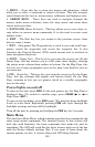
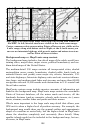
The Zoom In and Zoom Out keys zoom the map to enlarge or reduce its
coverage area and the amount of mapping detail shown. There are 40
available map zoom ranges, from 0.02 miles to 4,000 miles.
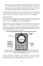
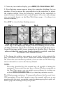
Far left, Map Page opening screen. Center, zoomed to 100 miles and
right, zoomed to 10 miles. Over Zoomed means you have reached the
detail limits in an area covered only by the basic background map.
Zooming in any closer will reveal no more map details because a high-
detail custom map has not been loaded on the MMC for this area.
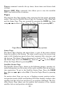
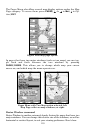
If you're using only the factory-loaded background map, the maximum
zoom range for showing additional map detail is 15 miles. You can con-
tinue to zoom in closer, but the map will simply be enlarged without
revealing more map content (except for a few major city streets.) Load
your own high-detail custom map made with MapCreate (or a pre-made
FreedomMap from LEI), and you can zoom in to 0.02 miles with mas-
sive amounts of accurate map detail.