


106
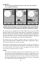
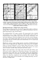
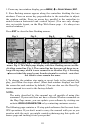
The cross track error range is shown on the compass rose as a wide,
white, corridor enclosing the course line. The outer edges of this white
corridor represent lines that show the current cross track error range.
The default for the cross track error range is 0.20 miles.
For example, if the present position symbol touches the right cross
track error line, then you are 0.20 miles to the right of the desired
course. You need to steer left to return to the desired course. You can
use the
ZIN or ZOUT keys to change the cross track error range.
A circular symbol depicting your destination (waypoint) appears on the
screen as you approach the waypoint, as shown on the screen in the
preceding figure.
Travel Time is the time that it will take to reach your destination at
your present closing speed. (You can also customize the time data box
to show Arrival Time instead. Arrival Time is the local time it will be
when you arrive at the destination, based upon your present closing
speed and track.)
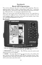
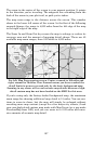
In the preceding example figure, the driver is headed northwest (a 345º
track) toward a waypoint 346º (bearing) away. The cross track error
range (white corridor) is 0.15 miles either side of the course. The driver
is headed toward trail waypoint 1, which is 0.3 miles away. The vehicle
is 234 feet right of the original course. Traveling at a speed of 17 mph,
the driver will arrive at the waypoint in 1 minute, 3 seconds.
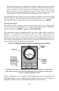
The Navigation Page has its own menu, which is used for some ad-
vanced functions and for setting various options. (Options and setup
are discussed in Sec. 8). To access the Navigation Page Menu, from the
Navigation Page, press
MENU.
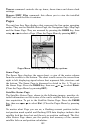
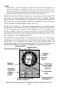
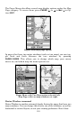
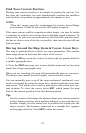
Map Page
The Map Page screens show your course and track from a "bird's-eye"
view. By default, this unit shows the map with north always at the top
of the screen. (This can be changed. See the topic Map Orientation, in
Sec. 8.) If you're navigating to a waypoint, the map also shows your
starting location, present position, course line and destination. You
don't have to navigate to a waypoint, however, to use the map.
Map Page is the default screen that appears when you turn on the unit.
To get to the Map Page from another page: Press
PAGES|→ or ← to
MAP|EXIT. When the Map Page is displayed, a screen similar to the fol-
lowing figures appears.