


103
WARNING:
Do not begin navigating with this unit until the numbers
have stopped flashing!
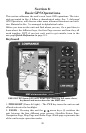
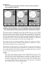
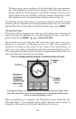
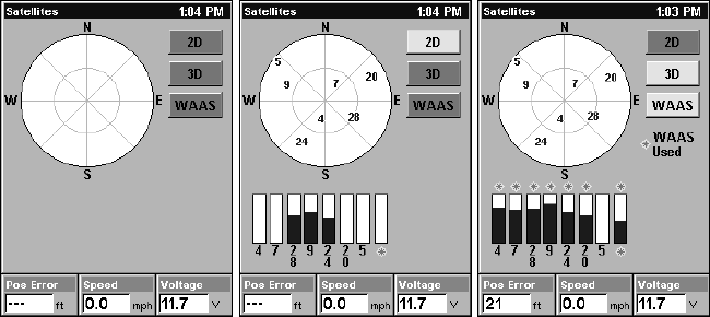
Satellite Status Page. Left view indicates unit has not locked on to any
satellites and does not have a fix on its position. Center view shows sat-
ellites being scanned. Right view shows satellite lock-on with a 3D posi-
tion acquired (latitude, longitude and altitude), and WAAS reception.
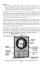
This screen shows a graphical view of the satellites that are in view. Each
satellite is shown on the circular chart relative to your position. The point in
the center of the chart is directly overhead. The small inner ring represents
45° above the horizon and the large ring represents the horizon. North is at
the top of the screen. You can use this to see which satellites are obstructed
by obstacles in your immediate area if the unit is facing north.
The GPS receiver is tracking satellites that are in bold type. The re-
ceiver hasn't locked onto a satellite if the number is grayed out, there-
fore it isn't being used to solve the position.
Beneath the circular graph are the bar graphs, one for each satellite in
view. Since the unit has twelve channels, it can dedicate one channel
per visible satellite. The taller the bar on the graph, the better the unit
is receiving the signals from the satellite.
NOTE:
One of the data display options for the Satellite Status page is "Po-
sition Error" (horizontal position error), which can appear in one of
the page's data boxes. Position Error will show you the expected er-
ror from a benchmark location. In other words, if the Position Error
box shows 50 feet, then the position shown by the unit is estimated
to be within 50 feet of the actual location.