


67
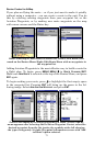
2. The Transfer My Data menu includes a message which tells you if an
MMC is present or not. If no MMC is present, you must first insert a
card into AirMap in order to activate the Load or Save commands.
To load data from the MMC to AirMap: press → to
LOAD|ENT.
3. Loading: There may be more than one GPS Data File (*.USR) on
the card. To select a file, press
ENT to activate the selection box, use ↓
or ↑ to highlight the file, then press
ENT to accept the selection. Next,
press ↓ to
LOAD|ENT. The unit will display a completion message when
the data transfer is finished. To return to the Page view, press
EXIT|EXIT|EXIT.
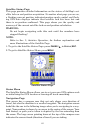
Navigate
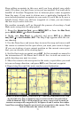
Navigation is one of the most powerful reasons for owning an AirMap,
and has already been addressed in Sec. 3. Land navigation is just as
useful, though. Just like the air navigation options, you can get accu-
rate information about where you want to go, how to get there, how
long it will take, and other useful trip information.
Navigate Back to Man Overboard Waypoint
In Land Mode, this unit has a man overboard feature that shows navi-
gation data to the location where the feature was activated. (This fea-
ture replaces Aviation Mode's "Find Nearest Airport" shortcut.) To ac-
tivate it, press the
ZOUT and ZIN keys at the same time. Your position
at the time these keys are pressed is used as the man overboard posi-
tion. The unit automatically begins navigating to the MOB waypoint.
Cancel Navigation
Press
MENU|MENU|↓ to CANCEL NAVIGATION|ENT|← to YES|ENT.
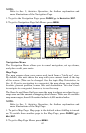
Navigate a Route
1. From the
NAVIGATION PAGE, press MENU|ENT or from the MAP PAGE,
press
MENU|MENU|↓ to ROUTE PLANNING|ENT.
2. Press ↓ to select route name|
ENT|↓ to NAVIGATE|ENT.
NOTE: To navigate a route in reverse: instead of the instructions in step
2, press ↓ to select route name|
ENT|↓ then → to REVERSE|ENT|← to
NAVIGATE|ENT.
3. Upon arrival at your destination, cancel navigation:
press
MENU|MENU|↓ to CANCEL NAVIGATION|ENT|← to YES|ENT.
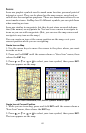
Navigate to Cursor Position on Map
1. Use arrow keys to center cursor cross-hair over the map object or
location.