


23
Each of the three main Pages also has a submenu screen associated
with it. You access a Page Submenu by pressing the
MENU key one time
while the page is displayed. (Pressing the
MENU key twice takes you to
the Main Menu.)
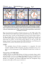
Several pages share similar display features. For example, the Naviga-
tion Page's HSI Map and the Map Page's Map Panel option both have a
VSI or Vertical Speed Indicator. To reduce redundancy in our text, we
will describe some of these duplicate features when discussing the page
on which they are most prominent.
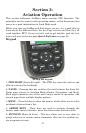
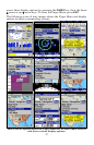
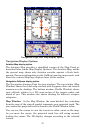
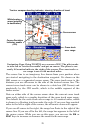
Satellite Status Page
This Page, shown in the following image, provides detailed information
on the status of AirMap's satellite lock-on and position acquisition. To
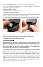
get to the Satellite Status Page: press
PAGES repeatedly until the page
you want appears.
No matter what page you are on, a flashing current position indica-
tor/question mark symbol and flashing GPS data displays indicate that
satellite lock has been lost and there is no position confirmed. This
page shows you the quality and accuracy of the current satellite lock-on
and position calculation.
WARNING:
Do not begin navigating with this unit until the numbers
have stopped flashing!
Satellite Page shows satellite-lock on with a 3D position acquired (latitude,
longitude and altitude) and WAAS corrections. The bottom of the screen
shows a battery power indicator with "E" for empty and "F" for full.
This screen shows a graphical view of the satellites that are in view.
Each satellite is shown on the circular chart relative to your position.
The point in the center of the chart is directly overhead. The small in-
ner ring represents 45° above the horizon and the large ring represents
the horizon. North is at the top of the screen. You can use this to see