


7
must be loaded from the MMC into memory before AirMap can use
them.)
As we mentioned earlier, the other key use for MMCs is storage of the
aeronautical databases and high-detail maps from MapCreate. These
Custom Map Files (file format *.lcm) can also be shared between Air-
Maps, other Lowrance GPS or sonar/GPS units and personal computers.
You make your own Custom Map Files with our MapCreate software,
but you don't have to. We also sell ready-to-use FreedomMaps. These
custom maps are pre-loaded on MMCs. (No computer work required!).
Introduction to GPS and WAAS
Well, now you know the basics of how AirMap does its work. You might
be ready to jump ahead to Section 2, Installation & Accessories, on page
11, so you can install the batteries. Or you might want to see how our
text formatting makes the manual tutorials easy to skim. If that's the
case, move on to "How to Use This Manual" on page 9. But, if you want
to understand the current state of satellite navigation, look over this
segment describing how GPS and its new companion WAAS work to-
gether to get you where you're going.
First of all, why are pilots so excited about GPS navigation? GPS is
more accurate than other navaids, such as VOR and NDB. GPS is free
of environmental limitations that affect other navigation systems and
it's available worldwide. GPS receivers like your AirMap are highly
affordable, easy to use and not confined to your cockpit! GPS frees a
pilot to accurately navigate to or from virtually any map place on earth
— navigation is no longer limited to the aeronautical navaid network.
With a mapping GPS, a pilot always knows exactly where he is. A GPS
receiver makes it easier for a pilot to apply wind correction angles and
fly true headings, as well as determine true ground speed.
The Global Positioning System (GPS) was launched July 17, 1995 by
the United States Department of Defense. It was designed as a 24-
hour-a-day, 365-days-a-year, all weather global navigation system for
the armed forces of the U.S. and its allies. Civilian use was also avail-
able at first, but it was less accurate because the military scrambled
the signal somewhat, using a process called Selective Availability (SA).
GPS proved so useful for civilian navigation that the federal govern-
ment discontinued SA on May 2, 2000, after the military developed
other methods to deny GPS service to enemy forces. Reliable accuracy
for civilian users jumped from 100 meters (330 feet) under SA to the
present level of 10 to 20 meters (about 30 to 60 feet).
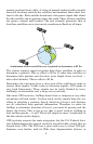
Twenty-four satellites orbit 10,900 nautical miles above the Earth,