


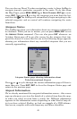
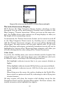

53
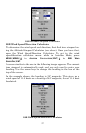
Airport Services screen for KTUL (Tulsa International).
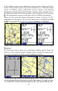
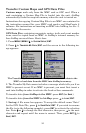
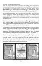
Terrain Awareness Display
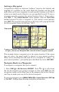
We'll discuss the Map Categories Drawn feature elsewhere in this
document, but one of the most powerful Aviation tools available is the
Map Category "Terrain Awareness." When you turn on this map cate-
gory, the AirMap draws color contours on all map displays to show you
the height of the surrounding terrain.
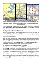
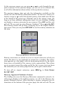
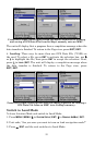
As mentioned, the Terrain Awareness feature can be turned on and off
in the Map Categories Drawn menu by checking (on) or unchecking
(off) the Terrain Awareness category. If you turn off the Background
subcategory, the map screens will not show shaded relief. If you turn
off the Warnings subcategory, potentially hazardous terrain will not be
highlighted in various colors. Removing these categories will allow you
to better distinguish the color coding of the Terrain Awareness.
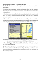
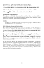
Color Code
As you fly, the AirMap notes your current altitude and the height of the
terrain below you. The relief map shows areas with different risk levels
in different colors, according to the following parameters:
Red highlight: indicates terrain that is at your current altitude or
higher.
Yellow highlight: indicates terrain 500 feet below your current altitude.
Green highlight: indicates terrain 1,000 feet below your current al-
titude.
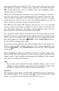
When flying over the ocean, the surface shading in the Profile Win-
dow reverts to a pattern of small Xs, indicating no risk of flying into
elevated terrain.
All map screens will show the terrain relief shading except for the
Navigation Panel and the Aviation Map option. On those screens, the
terrain awareness color highlight does appear.