


5
Plot Trails:.......................100 savable; up to 9,999 points in a single
trail.
Nearest Airport:.............Quickly locates an airfield closest to your
current position. (Aviation Mode only.)
Man Overboard: .............MOB feature precisely marks man overboard
location with special icon, then automatically
displays navigation data to that position.
(Land Mode only.)
Com Port:.........................One serial communications port, NMEA
0183 version 2.0 compatible. Allows ex-
change of position data with another device,
such as an autopilot or personal computer.
Optional combination serial/power cable
available.
Zoom range: ....................39 ranges; 0.02 to 4,000 miles.
NOTE:
The above memory capacities refer only to AirMap's on-board mem-
ory. The amount of GPS data you can record and save for recall later
is only limited by the number of MMC cards you carry with you.
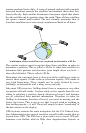
How AirMap Works
You'll navigate faster and easier if you understand how AirMap scans
the sky to tell you where you are on the earth — and, where you're go-
ing. (But if you already have a working understanding of GPS receivers
and the GPS navigation system, skip on ahead to Section 2, Installa-
tion & Accessories on page 11. If you're new to GPS, read on, and you
can later impress your friends with your new-found knowledge.)
First, think of your AirMap as a small but powerful computer. (But
don't worry — we made AirMap so easy to use, you don't need to be a
computer expert to find your way!) The unit includes a keypad and a
screen with menus so you can tell AirMap what to do. The screen also
lets AirMap show your location on a moving map, as well as point the
way to your destination.
This pocket-sized computer also contains an antenna and specialized
scanning receiver, something like your car radio. But instead of your
favorite dance tunes or VOR signals, this receiver tunes in to a couple
of dozen GPS satellites circling the earth. (WAAS satellites, too, but
more about them later.)
AirMap listens to signals from as many satellites as it can "see" above
the horizon, eliminates the weakest signals, then computes its location
in relation to those satellites. Once the AirMap figures its latitude and