


40
System Info
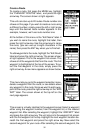
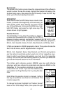
The system information screen shows the release date and the software’s
version number. To view this screen, highlight the System Info label on the
System Setup menu. Now press the right arrow key. Press the EXIT key
when you’re finished reading this screen.
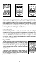
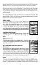
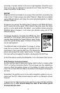
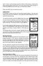
GPS SETUP
Items found under the GPS Setup menu include initial-
ization, (covered at the beginning of this manual), po-
sition format, power save, datums, and more. To use
any of these features, first press the MENU key, high-
light GPS Setup and press the right arrow key. The
screen shown at right appears.
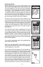
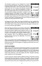
Position Format
The GlobalNav 12 can show the position in degrees,
minutes, and thousandths of a minute (36° 28.700') or
degrees, minutes, seconds, and tenths of a second (36° 28' 40.9"). It can
also show position in UTM (Universal Transverse Mercator) projection,
British, Irish, Swedish, Swiss, Finnish, New Zealand, and Military Grid.
UTM’s are marked on USGS topographic charts. This system divides the
Earth into 60 zones, each 6 degrees wide in longitude.
British, Irish, Swedish, Swiss, New Zealand, and Finnish grid systems
are the national coordinate system used only in their respective coun-
tries. In order to use these grid systems, you must be in the respective
country. This unit will pick the matching datum for you when you select the
grid. See the Datums section for more information.
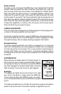
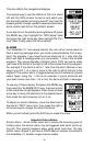
The military grid reference system (MGRS) uses two grid lettering
schemes, which are referred to as standard and alternate MGRS on the
GlobalNav 12. Your position and datum in use deter-
mines which one to use. If you use the standard, and
your position is off significantly, then try using the alter-
nate.
Note: When the position format is changed, it affects
the way all positions are shown on all screens. This
includes waypoints.
To change the format, highlight the “Position Format”
label on the “GPS Setup” menu, then press the right