


30
Project a Waypoint
You can save a waypoint even if you don’t know it’s
position or location on the plotter. This unit lets you
project the location of a waypoint from a known way-
point using only bearing and distance from the known
waypoint. This is useful if you don’t know the latitude/
longitude of a location, but you do know the distance
and bearing from a saved waypoint or your own posi-
tion.
(Note: To project a waypoint from your present posi-
tion, you must first save your present position as a
waypoint.)
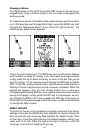
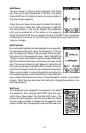
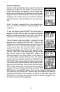
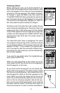
To use this feature, press the WPT key, then select a
waypoint number that you want to save the projected
waypoint under.Now select Project WPT from the Op-
tions menu. The screen shown at right appears.
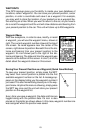
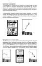
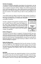
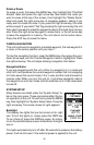
The unit needs a starting location to project the new
waypoint from. Highlight the “REF WPT” label on the
Project WPT menu and press the right arrow key. The
screen at the top of the next page appears. Select a
waypoint from either the waypoint number, newest, or
waypoint list. When you’ve chosen the waypoint, high-
light the “USE REF” label and press the right arrow
key. The unit returns to the Project WPT screen. The
starting waypoint you chose shows in the middle of
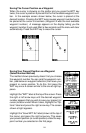
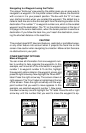
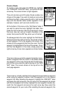
this screen. Now set the distance from the starting
waypoint to the projected waypoint by highlighting the
“SET DIST” label and pressing the right arrow key. Use
the arrow keys to set the distance, then press the ENT
key when you’re finished. The unit returns to the Project
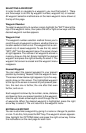
WPT screen. Now enter the bearing from the starting
waypoint to the projected waypoint by selecting “SET
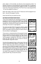
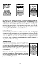
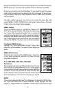
BRG” from the Project WPT screen. Once you’ve entered the bearing, the
unit returns to the Project WPT screen with the distance and bearing
showing at the bottom of the screen, as shown at right. Now press the
ENT key. The unit saves the projected location under the waypoint num-
ber that you picked at the beginning.