


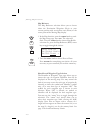

Search and
Rescue
When activated, the Search and Rescue (SAR) feature
allows a simplified, automated method of performing
search patterns. The search patterns supported
include parallel line, creeping line, and expanding
square. A line showing the route of the pattern may
also be displayed on the screen of your GX. Patterns
can be based on two grid types: aeronautical sectional
charts (US) and a Lat/Lon grid system (Basic). The
grid system can be displayed on the Moving Map, as
well as the search pattern.
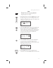
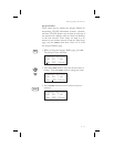
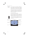
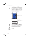
Search and Rescue Map Description
The Search and Rescue map page is essentially the
same as the regular full map with the addition of the
SAR features. However, at various zoom levels,
underlying waypoint information will not be shown
to allow for the display of SAR information. Smart
keys control the Grid Lines (GRD), mark a position
with a new User waypoint (MRK), and select a search
pattern (PAT).
4-14
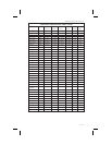
Moving Map Functions
GRD
426
ab
c
d
423
ab
c
d
394
ab
c
d
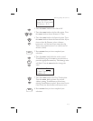
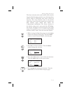
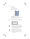
TO Waypoint
Identifier
Map Scale
Bearing to
the TO
Waypoint
Distance to
the TO
Waypoint
393
ab
c
d
Quarter Grid
Letter
Grid
Number
20
27.3
010
T
T
392
ab
c
d
391
ab
c
d
425
ab
c
d
424
ab
c
d
aTTD
GRD4MSG PATMRK
Plane Reference Icon
MRK
PAT