


Waypoint
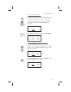
Distance Page
This page shows the cumulative distance from your
current position to each waypoint in the active flight
plan starting with the active leg. Turn the
SMALL
knob to view the next set of waypoints in your active
flight plan. The waypoint type is shown to the left of
the identifier. The allowable waypoint types are:
Airport (a), Intersection (i), NDB (n), and VOR (v).
The waypoint type symbol will not be shown if one of
the following occurs: the waypoint identifier is
unknown, it is an approach waypoint that is not one
of the four used types, it is a User waypoint, the
waypoint is not recognized by the current data card’s
database, or the data card has been removed.
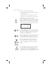
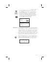
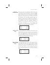
aSLE ------nm
aPDX 43nm
aSEA 154nm
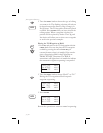
Waypoint ETE
Page
This page displays the cumulative time in hours and
minutes from your current position to each waypoint
in the active flight plan, starting with the active leg.
Turn the
SMALL knob to view the next page of
waypoints. The time will not be shown for the same
reasons as in the Waypoint Distance page.
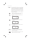
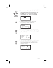
aSLE ete--:--
aPDX ete00:25
aSEA ete01:32
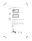
From-To-Next
Waypoint ETA
Page
This page displays the ETA for each waypoint in your
active flight plan from your current position, starting
with the active leg. Turn the
SMALL knob to view the
next page of waypoints. The time will not be shown
for the same reasons as in the Waypoint Distance
page, if the ground speed is zero, or if 3-D positioning
is lost.
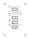
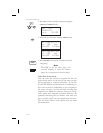
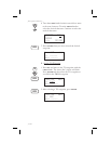
aSLE eta--:--
aPDX eta12:15
aSEA eta13:32
3-25
Navigation Basics