


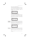
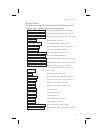

Nav Page Choices
The following displays are available when customizing your Nav
displays. Page references are shown in parentheses.
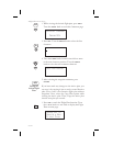
Ete aUAO 02:27 Estimated Time En Route to TO 4wpt ()
Eta aUAO 00:02 Estimated Time of Arrival to TO wpt (9)
Eta aCVO 00:22 Estimated Time of Arrival to last wpt in plan
Ft00:04 Elapsed Flight Time (9)
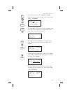
Trk 318 357 Track Angle and Bearing (7 and 4)
1.74 崬 Cross Track Error (numeric & graphic) (5)
00:00 UTC Universal Coordinated Time (9)
--:-- to Descent Time to beginning of Descent (17)
____’Above Hold Feet Above Hold Altitude (16)
EnrtSafeA 7700’ Minimum Safe Altitude (Entire route) (8)
Min SafeA 4300’ Minimum Safe Altitude (Present Position) (8)
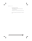
Baro Alt 5100ft Barometric altitude (pressure altitude
corrected for local altimeter setting) (15)
______ Blank field
aTTD Destination (TO) Waypoint
Brg 071½ Bearing and Relative Bearing Indicator (3)
12.7nm Distance to TO wpt in nautical miles (4)
21.9km Distance to TO wpt in kilometers
12.8mi Distance to TO wpt in statute miles
Trk 070 Track Angle (7)
Tae 000 Track Angle Error (7)
330 kts Speed in knots (7)
612kph Speed in kilometers per hour
380mph Speed in miles per hour
GroundSp 330kts Ground Speed (kts, kph, or mph)
Dtk 193 73.5nm Desired Track and Leg Distance (nm or km)
(6)
7-5
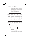
System Functions