


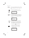
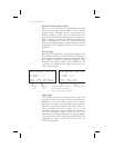

Estimated Time En Route (Ete)
ETE is to the current TO (destination) waypoint
from your present position based on the current
ground speed. The units shown are in hours and
minutes, 00:00 to 99:59, and in seconds when less
than one hour is displayed. If the ground speed is less
than or equal to 5 knots, the GPS receiver does not
have a valid position, or there is no TO waypoint, the
ETE value will be shown as dashes. If there is no TO
waypoint, the TO identifier location will be replaced
by dashes.
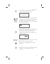
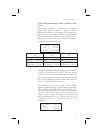
Bearing (Brg)
Bearing is the angle from your present position to the
TO waypoint. Bearing is shown from 0 to 359 degrees
in one degree increments. Bearing is computed using
the magnetic variation at the Present Position. The
Bearing value will be dashed if the FROM or TO
waypoints are blank or the GPS receiver does not
have a valid position.
Range (Rge)
The distance from your present position to the TO
waypoint. Units can be set as either nautical miles or
kilometers in the Nav Info section of the System
functions (see page 6). Nautical mile units are 0.00 to
9.00 nm in 0.01 nm increments, 10.0 to 99.9 nm in 0.1
nm increments, and 100 to 9999 nm in 1 nm
increments. Kilometer units are 0.00 to 99.99 km in
0.01 km increments, 100.0 to 999.9 km in 0.1 km
increments, and 1000 to 9999 km in 1 km increments.
The Range value will be dashed if the FROM or TO
waypoints are blank or the GPS receiver does not
have a valid position.
3-4
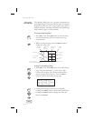
Navigation Basics
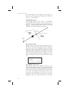
Bearing
Value
Bearing
Label
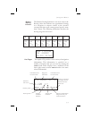
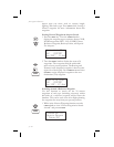
ete aEUG 00:16
1.120
Brg 173 45.5nm
“¼º
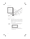
·
Bearing listed in the direction
you are off-course (value will
switch to either side as required)
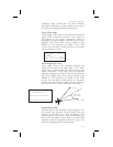
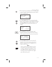
ete aEUG 00:16
1.120
173 Trk172
“¼º
Track Angle Value