


Approach Notes
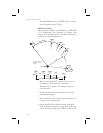
Waypoints The database waypoints which describe the TSO
C129a GPS approaches correspond with the
waypoints which appear on the approach procedure
charts whenever possible. VORs, NDBs, and named
Intersections will appear in the approach sequence as
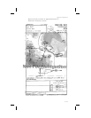
they are on the charts. The Rifle, Colorado VOR will
be identified RIL, the Turno Locator/Outer-Marker
(LOM) at Salem, Oregon will be identified SL, the
Forsyth NDB, at Forsyth Montana will be identified
FOR, and the HIKOX intersection, used as an Initial
Approach Fix (IAF) for VOR/DME or GPS RWY 3
approach at Casper Wyoming, will be identified as
HIKOX.
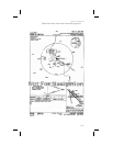
Many waypoints that are specific to TSO C129a GPS
approaches require that a name be assigned to them,
such as an Initial Approach Fix (IAF) which is shown
on the approach procedure chart as a radial and
distance from a VOR. These waypoints may or may
not appear on the approach procedure charts.
Jeppesen includes the names of many of these
waypoints on their approach procedure charts;
however, these names are usually not included on
National Ocean Service (NOS) charts.
TSO C129
Overlay
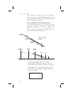
TSO C129 requires the equipment to prompt the
pilot to enter the local altimeter setting, if not already
entered, at 3 nm inbound to Final Approach Fix,
FAF. It also requires that the equipment change
RAIM alarm limits from 1 nm to 0.3 nm and to begin
changing CDI sensitivity from 1 nm full-scale
deflection to 0.3 nm full-scale deflection when 2 nm
inbound to the FAF. The TSO also requires that the
final leg of the approach be defined as a path between
the FAF and the MAP waypoints (bearings to or from
waypoints are not allowed for the final segment). For
these reasons, a GPS TSO C129a approach must
always have an FAF lying on the inbound course to
the MAP, even when there is no such waypoint in the
9-77
Approach Notes