


Glossary
A Altitude (GPS ALT): Altitude, as calculated by the
Apollo GX, based upon a mathematical model of the
earth’s surface curvature. A substantial difference
between this altitude value and altitude referenced
to sea level may exist.
Altitude Assist: An aid that provides guidance in
descending from one altitude to another. See the
Altitude Assist description on page 14 for details.
Almanac: Data transmitted by a GPS satellite
including orbit information on all satellites, clock
correction, and atmospheric delays.
ARC: A DME arc terminator with the preceding
flight plan leg is described as an arc to this waypoint.
An ARC waypoint may follow another ARC
waypoint.
ATC Ring: On the map display, an artificial ring five
nm in diameter is drawn around airports that have a
control tower.
Automatic Terminal Information Service (ATIS):
Recorded information about weather and other
conditions at an airport, periodically updated when
conditions change.
Autonav: The function that allows you to set the GX
to scroll automatically through selected navigation
displays .
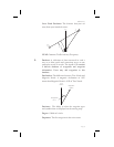
Azimuth: an arc, as measured clockwise from true or
magnetic north.
B Baro Altitude: Barometric altitude (pressure altitude
corrected for local altimeter setting). This altitude
should match the altitude displayed on your aircraft
altimeter.
Glossary
15-1