


N Nautical Mile (nm): A distance measurement equal
to 6,076 feet, or 1.15 statute mile. One nautical mile is
also equal to one minute of latitude.
NAVSTAR: The name given to GPS satellites formed
from the acronym for NAVigation System with Time
And Ranging.
Non-Directional Beacon (NDB): A low
frequency/medium frequency navigation aid sending
non-directional signals that can be used for
navigation.
O OBS: Omni-Bearing Selector.
P Parallel Track Offset: A course that is parallel to the
designated course, but offset to the right or left by a
given distance.
PDOP: Position Dilution of Precision. See Dilution of
Precision.
PRN: GPS satellite Pseudo-Random Numbers are
used to uniquely identify satellites. This is different
than the SVN (Space Vehicle Number, or satellite
serial number). When excluding satellites from the
RAIM Prediction , use the PRN number found on the
NOTAMs and NANUs, not the SVN.
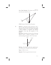
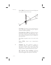
R Radial: Any of the 360 magnetic courses from a VOR or
similar navigational aid, beginning at the navigational
aid and proceeding outward in a straight line.
RAIM: Receiver Autonomous Integrity Monitoring. A
method of predicting possible system accuracy errors
that may be caused by bad satellite data. The RAIM
algorithm requires that more satellites are available and
usable than required for a normal GPS position fix.
Range: The distance from the present position to a
destination waypoint.
15-8
Glossary