


Reference
60
GPS Info Page
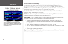
To select a new location:
1. Select ‘New Location.’ A window appears with two options (‘Automatic’ and ‘Use Map’).
2. Select either ‘Automatic’ or ‘Use Map.’ Selecting ‘Automatic’ puts the unit in Autolocate mode and begins
searching the sky for satellites. For ‘Use Map,’ a ‘New Location’ map page appears.
3. If ‘Use Map’ is selected, pan and zoom the map pointer on the map to find your approximate location.
Then touch the checkmark in the upper right-hand side of the page.
New Elevation – Allows you to designate your approximate elevation when the StreetPilot is acquiring
satellites or navigating within a two-dimensional position. By default, 2D navigation attempts to use the last
known elevation. If the elevation shown is off by several hundred feet (or more), manually entering your
approximate elevation enables the receiver to more accurately determine a position fix. Once the unit has a
3D position, you cannot enter an elevation.
Enable WAAS – Allows you to improve position accuracy by using Wide Area Augmentation System
(WAAS) capability. WAAS is a system of satellites and ground stations that provide GPS signal corrections,
giving you even better position accuracy (an average of up to five times better). A WAAS-capable receiver
can give you a position accuracy of better than three meters 95 percent of the time. WAAS corrects for GPS
signal errors caused by ionospheric disturbances, timing, and satellite orbit errors, and it provides vital
integrity information regarding the health of each GPS satellite.
WAAS consists of approximately 25 ground reference stations positioned across the United States that
monitor GPS satellite data. Two master stations, located on either coast, collect data from the reference
stations and create a GPS correction message. This correction accounts for GPS satellite orbit and clock
drift plus signal delays caused by the atmosphere and ionosphere. The corrected differential message
is then broadcast through one of two geostationary satellites, or satellites with a fixed position over the
equator. The information is compatible with the basic GPS signal structure, which means any WAAS-
enabled GPS receiver can read the signal.
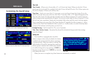
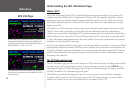
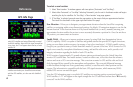
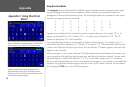
View the GPS Information page to see which GPS satellites are receiving position corrections from the
WAAS satellites. A “D” will appear on the signal strength bar for GPS satellites that have been “Differentially
corrected” via the WAAS satellites.
A ‘D’ on various signal strength bars above indicate
which GPS satellites are being differentially corrected
via WAAS satellites. Note that if the signal strength bar
is too short, the ‘D’ will appear above the bar, as with
satellite 26.
GPS satellites can be differentially corrected via WAAS
satellites even before your StreetPilot communicates
with the GPS satellites, as is the case with Satellite 5,
above.