


Reference
12
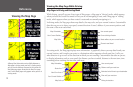
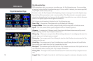
Viewing the Map Page While Driving
Map Pages in Driving and Routing Mode
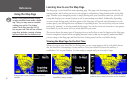
While driving, you will see one of two types of Map pages: a Map page in “driving” mode, which appears
when you have the StreetPilot turned on but you are not navigating a route, and a Map page in “routing”
mode, which appears when you have created a route and are currently navigating to it.
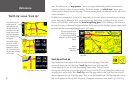
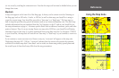
In driving mode, the Map page shows map details, the map scale, and your current location. Customizable
data tabs are pre-set to show your speed, current direction of travel, address of your current position, and
the name of the next road ahead.
In routing mode, the Map page displays more information. It graphically shows you map details and your
current location, and it marks your route to a destination with a magenta-colored route line. It tells you
what direction to go as well as the direction in which you are traveling. Customizable data tabs are pre-set
to display information such as your speed, the distance you have traveled, distance to the next turn, time
remaining before reaching the next turn, and more.
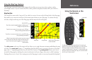
Your current speed
Distance until your next turn
Estimated arrival time to your destination
Time until your next turn
Driving instructions
Map Orientation
Route Line
Next Turn Arrow
Your Current Position
Map Scale
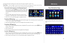
Viewing the Map Page
Your current speed
Current driving direction
Street address at your current location
The next road ahead
Map Orientation
Your Current Position
Map Scale
Map page in driving mode
Map page in routing mode
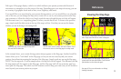
Although the information varies slightly between a
Map page in driving mode and one in routing mode,
you can use the features discussed in this section for
both Map page types. Note that the Next Turn page
and Current Route pages only appear when you are in
routing mode.