


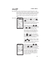
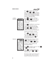
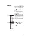
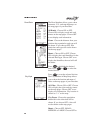
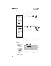
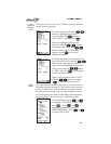
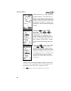
Press the button to highlight the Map Datum Type and
then press or to select the desired Map Datum.
The following list shows the GPS map datums contained
within the Precedus. Each map datum represents a
mathematical model of the earth used for the purpose of
establishing precision in charting various areas of the earth.
Since each datum relies on a different mathematical model,
inconsistencies exist in defining the location of charted
points between datums. For this reason, it is important to
verify that you have selected the correct map datum for the
area where you navigate and the chart you use.
Note
WGS-1984 is the default datum until you change
it.
Datum Name Ellipsoid
(Model)
ARC 1950 Clarke 1880
ARC 1960 Clarke 1880
Australian Geodetic 1966 Australian National
Australian Geodetic 1984 Australian National
Bogota Observatory International
Campo Inchauspe International
Cape Clarke 1880
Carthage Clarke 1880
Chatham 1971 International
Chua Astro International
Corrego-Allegre International
European 1950 West Europe International
European 1950 Cyprus International
European 1950 Egypt International
European 1950 Iran International