


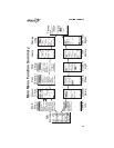

Map SetupsThis option controls the type of waypoints that show on the
moving map screens, the size of the text, whether or not a Route
Path or Airspaces are shown, and the orientation of the moving
map. The pages available in Map Setup include Misc Setup,
Aviation Wpts, Airspaces, Road Data, City Wpts, and User
Wpts.
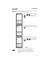
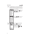
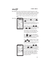
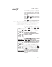
Misc Setup Highlight “MAP SETUP” in the Main
Menu and press . Use the
buttons to select the desired Map
Setup page. If you do not have a
particular database loaded, the setup page
for that database with not be shown.
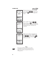
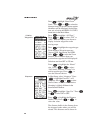
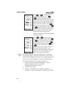
In MiscSetup, press the
buttons to highlight “Route Off/On.” Press
the or button to select “On” or
“Off.” With Route turned On, a line
representing your intended flight path
shows on the moving map screens to aid
you in navigating to your destination.
Press to highlight “Route Idents.”
Press or to select “Off, Small,
Medium, or Large.” This sets the size that
text will appear on the map displays.
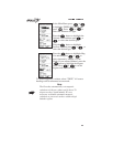
Press to highlight “Orient.” Press
or to select “Track, DTK
(Desired Track), or North” for the top of
the screen on the moving maps.
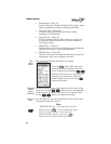
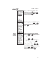
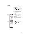
In MiscSetup, press the
buttons to highlight “Extended Pan Wpt.”
Press the or button to select the
type of waypoint that will be displayed in
Pan mode when the Zoom scale displays an
area outside of the currently viewable
waypoints. Waypoint types available are:
None, Int, Arpt, VOR, NDB, and City.
Normally, the neaerest 30 waypoints of
each type are shown.