


69
Section 3
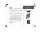
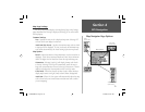
GPS Navigation
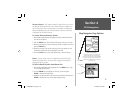
The Panning Arrow (Map Pointer)
The Panning Arrow is controlled by the ARROW keys and is used
to identify map objects and move the map in order to view areas of the
map not currently within the display. The Panning Arrow can be used
to establish a ‘Point of Reference’ when measuring distance between map
items. It can be used to create a waypoint or to move a waypoint to a new
location. Press the ARROW keys at an angle to move diagonally. Press and
hold the ARROW keys to move to new areas of the map. Press the CLEAR
key to cancel the panning arrow.
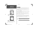
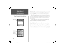
Using the Panning Arrow:
The Map Page pan function allows you to display an arrow to point at
and identify items on the map, and to move the map in order to view areas
beyond the current viewing area on the display.
The pan function is activated by the ARROW keys which move the
arrow in the desired direction. As the arrow moves to the edge of the dis-
play screen the map will also move to reveal more map area. When moving
to the edge of the display, the map will take some time to draw the new
area of the map. An hourglass will display in place of the panning arrow
when the map is redrawing.
Pressing the CLEAR key cancels the pan function.
The detail of map features will be enhanced when you are using
MapSource information loaded on a map data card. When using any map
data, whenever the panning arrow is placed on a map item, the name of the
object will be highlighted. This feature applies to waypoints, roads, lakes,
rivers...almost everything that is displayed.
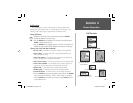
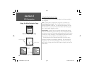
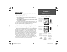
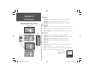
The Panning Arrow
or
(Map Pointer)
The Panning Arrow
The Panning
Arrow moves
about on the Map
Page as you press
the ARROW key
in the desired
direction.
ARROW key
Section 4
NvTlkGSMManual copy.indd 69 12/2/2002, 8:42:57 AM