


69
Reference
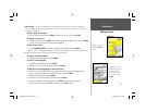
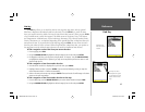
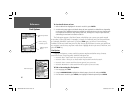
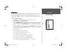
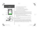
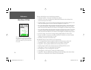
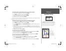
Main Menu: GPS Tab
WAAS Capability
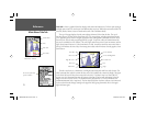
The GPSMAP 188/188C/238 Sounder is capable of receiving WAAS (Wide Area Augmentation
System) satellite signals. WAAS is an FAA (Federal Aviation Administration) funded project to improve
the overall accuracy and integrity of the GPS signal for aviation use, but land/sea based users may also
benefi t from this system. At this time, the system is still in the development stage and is not fully opera-
tional. There are currently two WAAS satellites that can be received in the U.S.A., one over the Atlantic
Ocean and one over the Pacifi c Ocean, in a geo-stationary orbit over the equator. Effective use of the
WAAS satellite signal may be limited by your geographic location in relation to those satellites, now in
developmental service. WAAS satellite signal reception requires an absolute clear view of the sky and
works best when there are no nearby obstructions such as buildings, mountains, etc. WAAS satellites
will be numbered 33 or higher when viewing the sky view on your GPSMAP 188/188C/238 Sounder.
Initial reception of the WAAS signal may take up to 15-20 minutes, then 1-2 minutes afterwards. When
WAAS differential correction has been received for GPS satellites (numbers 32 or below), a ‘D’ appears
in the signal bar of the sky view and ‘2D or 3D Differential’ appears in the receiver status. To learn more
about the WAAS system, its satellite positions and current state of development, visit the FAA web site
(http://gps.faa.gov). Since WAAS requires CPU resources of the GPSMAP 188/188C/238 Sounder to
search for and track the satellites, you may disable the WAAS feature to improve unit performance if
WAAS reception is not available in your area.
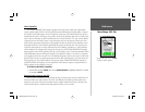
To disable/enable WAAS capability:
1. From the GPS tab, press MENU, then use the ARROW KEYPAD to highlight ‘WAAS Off’ or ‘WAAS
On’ and press ENTER.
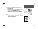
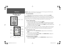
Receiver Status, Accuracy and DOP
Receiver status is indicated at the top fi eld of the page, with the current Accuracy and Dilution Of
Precision (DOP) to the right of the sky view. DOP is an indication of satellite geometry quality mea-
sured on a scale of one to ten (lowest numbers the best, highest numbers the poorest). Accuracy uses
DOP and other factors to calculate horizontal position accuracy in feet or meters.
Highlight ‘WAAS Off’ and press ENTER
to disable the WAAS capabilities.
188188C238 Manual Part 2.indd 69 6/30/2003, 3:32:20 PM