


104 GPSMAP 3206/3210 Owner’s Manual
aPPendIX > dIgItal selectIve callIng (dsc)
appendIX
WAAS Capability
The GPSMAP 3206/3210 is capable of receiving WAAS satellite signals. WAAS
is an FAA (Federal Aviation Administration) funded project to improve the
overall accuracy and integrity of the GPS signal for aviation use, but land and
sea-based users can also benet from this system.. There are currently two WAAS
satellites that can be received in the U.S.A., one over the Atlantic Ocean and one
over the Pacic Ocean, in a geostationary orbit over the equator. Effective use of
the WAAS satellite signal may be limited by your geographic location in relation
to those satellites, now in developmental service. WAAS satellite signal reception
requires an absolute clear view of the sky and works best when there are no
nearby obstructions such as buildings or mountains.
WAAS satellites are numbered 33 or higher when viewing the sky view on your
GPSMAP 3206/3210. Initial reception of the WAAS signal may take up to 15-
20 minutes, then 1–2 minutes afterwards. When WAAS differential correction
has been received for GPS satellites (numbers 32 or below), a “D” appears
in the signal bar of the sky view and “Ready For Navigation with WAAS”
appears in the Status eld. To learn more about the WAAS system, its satellite
locations and current state of development, visit the FAA web site (gps.faa.gov).
Because WAAS requires CPU resources of the GPSMAP 3206/3210 to search
for and track the satellites, you can disable the WAAS feature to improve unit
performance if WAAS reception is not available in your area.
To disable or enable WAAS capability:
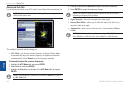
1. OntheGPStab,highlighttheSetupsubtab.
2. UsetheROCKERtohighlighttheWAASeld,andpressENTER.
3. HighlightOnorOff,andpressENTER.
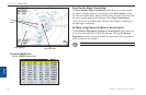
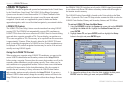
Digital Selective Calling (DSC)
When the Garmin GPSMAP 3206/3210 is connected to a VHF radio with DSC
support, the GPS unit displays a Call List, Log, and a Directory to store incoming
information received from another user’s DSC capable VHF/GPS combination.
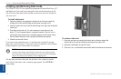
Basic wiring is required for the Garmin unit and VHF radio to send and receive
NMEA data from each other. See the GPSMAP 3206/3210 & GPS 17 Installation
Instructions.
What is DSC?
DSC uses marine VHF radio and GPS technologies to transmit and receive
location information. DSC is used by mariners to assist them in two major areas:
distress calls and position reporting.
A non-emergency DSC position report allows mariners to exchange and display
the positions of other boats. When a DSC position is received, the mariner can
choose to create a waypoint or to show the received position on an electronic
map.
An emergency DSC distress call allows a vessel in trouble to transmit a
substantial amount of information in a single transmission or “call” without
the need for voice communication. When any nearby rescuer receives the DSC
signal, an alarm sounds, and they immediately receive the position of the caller.
The rescuer can then choose to navigate (Go To) the callers position to assist or
forward the call on to the Coast Guard. When the Coast Guard receives the call,
they can immediately access the callers information (such as who they are and the
type of vessel) in their database while they are in transit to the caller’s position.
This makes DSC a time-saver, especially in an emergency situation. To use DSC,
users must rst register their VHF radio with the FCC and receive a Maritime
Mobile Service Identity (MMSI) number.