


GPSMAP 3206/3210 Owner’s Manual 103
aPPendIX > satellIte InforMatIon and what Is waas/egnos?
appendIX
Satellite Information
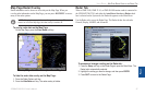
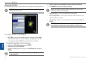
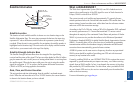
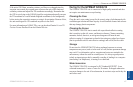
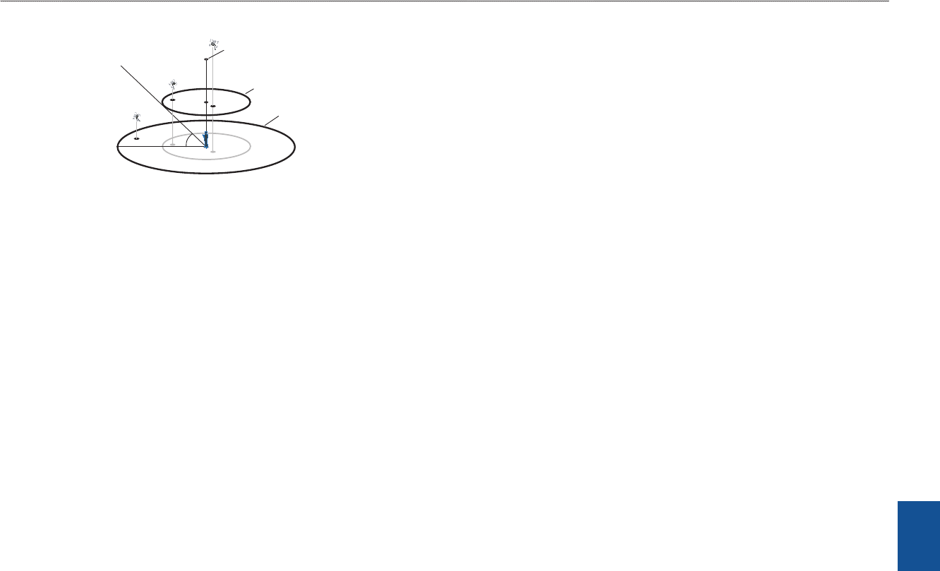
Satellite Sky View
45°
90°
Outerring-
thehorizon
Innerring-45°
abovethehorizon
Centerdot-90°
abovethehorizon
Satellite Location
The location of each available satellite is shown over two location rings on the
Satellite Information Page. The outer ring represents the horizon, the inner ring
represents 45° above the horizon, and the center dot represents a point directly
overhead. When the unit is using a satellite for navigation, the satellite number is
highlighted on the location rings. The unit can be set to display satellite location
with North or your current track at the top of the display.
Satellite Strength Indicator Bars
The Satellite Strength Indicator Bars show the strength of the signal being
received and the status of the signal. The bars are either shaded or lled. A hollow
gray bar means the unit is in the process of storing orbital data it is receiving from
the satellite signal. When the bar turns solid green, the unit is using the satellite
signal for navigation. A “D” in or above the bar means differential corrections
(WAAS or DGPS) are being applied to that satellite.
Date, Time, and Current Location
The unit gets date and time information from the satellite’s on-board atomic
clock. When the unit has achieved a 2D or 3D GPS location, the current location
is shown in the location format you have selected
What is WAAS/EGNOS?
The Wide Area Augmentation System (WAAS) is an FAA-funded service to
improve the overall integrity of the GPS signal for users in North America. In
Europe, WAAS is referred to as EGNOS.
The system is made up of satellites and approximately 25 ground reference
stations positioned across the United States that monitor GPS satellite data. Two
master stations, located on either coast, collect data from the reference stations
and create a GPS data correction message.
According to the FAA’s Web site, testing of WAAS in September 2002 conrmed
an accuracy performance of 1–2 meters horizontal and 2–3 meters vertical
throughout the majority of the continental United States and portions of Alaska.
WAAS is just one service provider that adheres to the Minimum Operational
Performance Standard (MOPS) for global Satellite Based Augmentation Systems
(SBAS). Eventually there will be several services of worldwide geostationary
communication satellites that broadcast integrity information and differential
correction data as transmitted by ground reference stations.
All SBAS systems use the same receiver frequency; therefore any operational
SBAS system should be capable of providing your GPS unit with increased
accuracy at any location in the world.
Currently, enabling WAAS on your GPSMAP 3206/3210 in regions that are not
supported by ground stations may not improve accuracy, even when receiving
signals from an SBAS satellite. In fact, it can degrade the accuracy to less than
that provided by GPS satellites alone. For this reason, when you enable WAAS
on your Garmin GPS receiver, the receiver automatically uses the method that
achieves the best accuracy.
For more information, go to gps.faa.gov.