


8-1
8. MENU SETTINGS
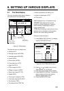
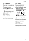
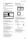
8.1 GPS SETUP Menu
Menu description
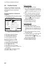
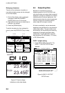
Fix mode
Two position fixing modes are available: 2D
and 2/3D. The 2D mode provides two
dimensional position fixes (latitude and
longitude only) and is used when three
satellites are in line of sight of the GPS
receiver.
The 2/3D mode switches between two and
three dimension position fixing automatically
depending on how many satellites (three or
four) are in line of sight of the GPS receiver.
ANT Height
Enter the height of the antenna unit above
sea surface (000-999 ft, 000-304 m). The
default setting is 16 ft.
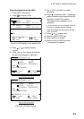
Disable satellite
Every GPS satellite is broadcasting
abnormal satellite number(s) in the Almanac.
Using this information, the GPS receiver
automatically eliminates any malfunctioning
satellite from the GPS satellite schedule.
However, the Almanac sometimes may not
contain this information. You can disable an
inoperative satellite manually on the GPS
SETUP menu.
GPS smoothing, position
When the DOP or receiving condition is
unfavorable, the GPS fix may change greatly,
even if the vessel is dead in water. This
change can be reduced by smoothing the
raw GPS fixes. A setting between 0 and 9 is
available. The higher the setting the more
smoothed the raw data, however too high a
setting slows response time to change in
latitude and longitude. This is especially
noticeable at high ship’s speeds. "0" is the
normal setting; increase the setting if the
GPS fix changes greatly.
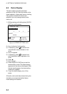
GPS smoothing, speed
During position fixing, ship’s velocity (speed
and course) is directly measured by
receiving GPS satellite signals. The raw
velocity data may change randomly
depending on receiving conditions and other
factors. You can reduce this random
variation by increasing the smoothing. Like
with latitude and longitude smoothing, the
higher the speed and course smoothing the
more smoothed the raw data. If the setting is
too high, however, the response to speed
and course change slows. For no smoothing,
enter "0." "5" is suitable for most conditions.
Speed average
Calculation of ETA and TTG, etc. is based on
average ship’s speed over a given period.
The default setting is one minute. Change
the setting if the ETA seems wrong.
RAIM function/RAIM accuracy
RAIM (Receiver Autonomous Integrity
Monitoring) is a diagnostic function which
tests the accuracy of the GPS signal within
the range set with "RAIM Accuracy" on the
GPS SETUP 2/2 menu. The receiver
displays (provided the RAIM function is
active) three levels of position confidence
according to the results of the test as shown
below. "CAUTION" indicates that RAIM could
not be assessed. In this case, provided the
GPS signal is normal, GPS position is safe
to use.