


-4.17-
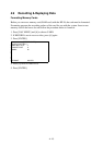
4.10 Initial Settings
An item on the PLOTTER DISP SELECT menu can be deleted through the VIDEO
PLOTTER INITIAL SETTING menu.
1. Press [NAV MENU].
2. Press [0] twice to display the VIDEO PLOTTER INITIAL SETTING menu.
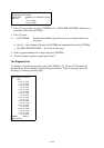
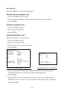
[VIDEO PLOTTER INITIAL SETTING]
1 [VIDEO PLOTTER 2]
2 DANGER HIGHLIGHT ON/OFF
3 COASTLINE ON/OFF
4 LAND DENSITY ON/OFF
5 PLACE NAME ON/OFF
6 MARK ON/OFF
7 OWN SHIP PLOT ON/OFF
8 TARGET PLOT ON/OFF
9 CONTOUR LINE ON/OFF
0 GRID ON/OFF
3. Press appropriate numeral key to turn on or off item.
4. Press [ENTER].
5. Repeat 3 and 4.
NOTE:
If Video Plotter fails to provide intended functions, turn ON the required functions on this
menu.
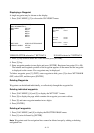
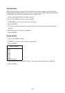
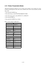
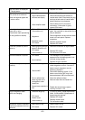
4.11 Latitude Error Table (on 96 nm range scale)
The longitude lines concentrate on the north pole and south pole, namely, 1 nm is equivalent
to 1 minute at 0 degree latitude, 2 minutes at 60 degrees latitude, 3 minutes at 70 degrees
latitude and so on. For this reason, a longitude error occurs on the radar display. For example,
when own ship is at 60°N and 135°E, even if the cursor indication is 62°N and 139°E, the real
cursor position is deviated to left (west) side. The table below shows the longitude error,
represented from 0° to 90° at 96 nm from the radar center (own ship).
62°N62°N
60°N
135°E
139°E
Real crsor position
Crsor position
indicated
LAT
E
Real crsor position
Crsor position
indeicated
96 nm
θ
OS position
R: Error