


-4.5-
2. Press appropriate numeral key to select both item and option. Press [ENTER] to register
selection.
For "OWN SHIP POSN" (manual input of position), do the following;
1) Press [4].
2) Enter latitude in seven digits.
3) Press [ENTER]. (If necessary to change to coordinate, press [4] and press [ENTER]).
4) Enter longitude in eight digits.
5) Press [ENTER]. (If necessary to change to coordinate, press [5] and press [ENTER]).
3. Press [0] to go to next page, the NAV INFORMATION 2 menu. Select options as you did
on the previous menu. To return to the previous menu, press [1].
[NAV INFORMATION 2]
1 [NAV INFORMATION 1]
2 WIND GRAPH OFF/ON
3 WIND UNIT m/s/KT
4 CURRENT DATA OFF/ON
5 CURRENT GRAPH OFF/ON
6 DEPTH DATA OFF/ON
7 DEPTH GRAPH OFF/ON
8 [DEPTH SCALE 10/20/50/100/200/500
9 DEPTH UNIT* m/ft
0 [NAV INFORMATION 3] *: Fishing mode only (one type of R-type)
4. Press [0] to display the NAV INFORMATION 3 menu.
[NAV INFORMATION 3]
1 [NAV INFORMATION 2]
2 WATER TEMPERATURE* OFF/ON
3 DATE OFF/UTC/LOCAL
±xx.xH
4 USE WPL
NAV LINE/WP
5
6
5, 6: When the radar is a component of an INS.
5. To set time indication, press [3] key several time to select OFF, UTC or LOCAL and press
[ENTER].
6. Press [NAV MENU] to close the menu.
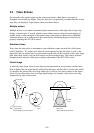
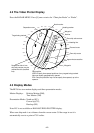
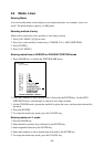
4.5 Track
This section provides the information necessary for setting the track display conditions of both
own ship and other vessels.
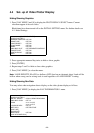
Stopping Plotting of Own Ship's Track
1.
Press [NAV MENU] and [5] key in order.
[OWN SHIP, TARGET PLOT]