


-4.4-
4.4 Set- up of Video Plotter Display
Hiding/Showing Graphics
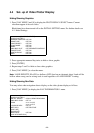
1. Press [NAV MENU] and [8] to display the PLOT DISPLAY SELECT menu. Current
selections appear in reverse video.
Blank items have been turned off on the INITIAL SETTING menu. For further details see
4.11 Initial Settings.
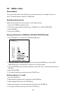
[PLOT DISP SELECT]
1 [VIDEO PLOTTER 1]
2 DANGER HIGHLIGHT OFF/ON
3 COAST LINE OFF/ON
4 LAND DENSITY OFF/ON
5 PLACE NAME OFF/ON
6 MARK OFF/ON
7 OWN SHIP PLOT OFF/SEPARATE/CONTINUE
8 TARGET PLOT OFF/ON
9 CONTOUR LINE OFF/ON
0 GRID OFF/ON
2. Press appropriate numeral key twice to hide or show graphic.
3. Press [ENTER].
4. Repeat steps 2 and 3 to hide or show other graphics.
5. Press [NAV MENU] to close the menu.
Note:
LAND DENSITY fills (ON) or hollows (OFF) land on an electronic chart. Land will be
hollow when wrong card or wrong scale is used regardless of LAND DENSITY setting.
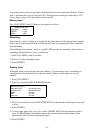
Hiding/Showing Nav Data
You may select what navigation data to display on the video plotter display as follows:
1. Press [NAV MENU] to display the NAV INFORMATION 1 menu.
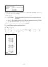
[NAV INFORMATION 1]
1 [VIDEO PLOTTER 1]
2 SELECT NAVAID GPS+LC/DEAD RECKONING
3 OWN SHIP POSN OFF L/L
4 POSN xx°xx.xxx N/S
xx°xx.xxx E/S
5 +CURSOR DATA OFF/L/L
6 WPT DATA OFF/REL/TRUE
7 [NAV LINE]
8 [WAYPOINT]
9 WIND DATA OFF/ON
0 [NAV INFORMATION 2]