


ii
Safety Information
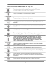
X Do not secure in front of airbag
X Do not loosely place on dashboard
X Do not block driver’s view
VOYA 350
The detailed mapping software is provided by NAVTEQ and Netropa. The detailed mapping
software is as accurate and detailed as possible. Whenever maps are digitized, there is still a
possibility that some inaccurate or incomplete data can be found. It is because of these
inaccuracies that the Voya 320 is a travel aid and is not intended for precise measurement in
navigation or aircraft use. Differences between manufactured and shipped versions of the
software may be present; this software may be updated frequently. If the descriptions in this
manual are different from your software version, please follow the software version currently on
hand.
Whistler VOYA 350
FCC Compliance
This device complies with Part 15 of the FCC Rules. Operation is subject to the following two
conditions:
(1) This device may not cause harmful interference, and
(2) this device must accept any interference received, including interference that may cause
undesired operation. This equipment has been tested and found to comply with the limits for a
Class B digital device, pursuant to part 15 of the FCC Rules. These limits are designed to provide
reasonable protection against harmful interference in a residential installation. This equipment
generates, uses and can radiate radio frequency energy and, if not installed and used in
accordance with the instructions, may cause harmful interference to radio communications.
However, there is no guarantee that interference will not occur in a particular installation. If this
equipment does cause harmful interference to radio or television reception, which can be
determined by turning the equipment off and on, the user is encouraged to try to correct the
interference by one or more of the following measures:
• Reorient or relocate the receiving antenna.
• Increase the separation between the equipment and receiver.
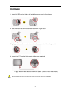
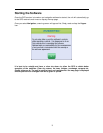
Introduction
Congratulations on your purchase of an Averatec Voya 320 GPS receiver! This system can
provide an auto route to the destination of your choice using signals from Global Positioning
Satellites (GPS) orbiting the earth.
There are 24 GPS satellites orbiting the earth. A GPS device can calculate your position on the
earth if it can receive signals from at least three of these satellites. When it receives at least four
signals, a GPS device can also calculate your altitude (height above sea level).
To use the GPS receiver for the first time you need to charge the battery for at least four hours.
The Voya 320 comes with maps preloaded on the SD card so map loading is not necessary.
Maps of other countries are sold separately.