


5
Read this first
R
ea
d
thi
s
fi
rs
t
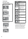
What you can do
with the GPS unit kit
The GPS-CS3KA GPS unit kit enables
you to:
– Apply positioning information to
image data
– Display images on a map of the
shooting locations
– Display the route you traveled on a
map
– Send e-mails with images displayed
on a map of the shooting locations
x
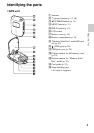
Components of the GPS
unit kit
The GPS unit kit consists of a GPS unit,
and three sets of application software:
“PMB,” “GPS Image Tracker,” and
“PMB Launcher.”
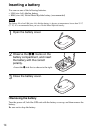
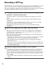
GPS unit
The GPS unit records the travel route as
a “GPS log,” a log of serial positioning
information. The GPS unit records the
current positioning information every 15
seconds in the “GPS log.”
You can also apply positioning
information to image data using the GPS
unit.
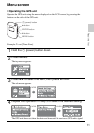
PMB
This software enables you to view and
manage the images recorded by digital
still cameras and Sony digital video
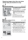
camera recorders. Using the Map View
feature of PMB, you can display images
which have positioning information
recorded by the GPS unit and
incorporated in the image data by GPS
Image Tracker, on a map. Thanks to this
feature, you can easily determine where
you took the image, and check the route
you traveled while recording images.
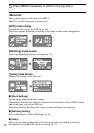
GPS Image Tracker
This software enables you to import the
“GPS log” (serial positioning
information recorded) from the GPS unit
to a computer, incorporate the
positioning information in the image data
recorded by digital still cameras and
Sony digital video camera recorders, and
store them together.
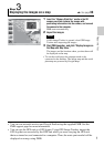
PMB Launcher
If you select an operation on the PMB
Launcher, the software required for the
operation starts automatically.
x
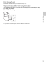
Matching positioning
information to individual
images
The GPS unit and GPS Image Tracker
match date and time information
recorded with the image data and that of
the GPS log, and pair positioning
information from the GPS log with
image data that has the same date and
time information as that of the GPS log
(Matching).
• Since the GPS unit records positioning
information every 15 seconds, the
positioning information applied to the image
may not be exactly the same as that where
the image was actually taken.
• The GPS unit records Greenwich Mean Time
(GMT) as the time information.
Notes