


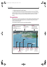


16 Navionics Platinum Chart Card - User’s Guide
• 3D OPTIONS
You can change the direction of the view (see
page 17
), adjust the exaggeration
(see
page 19
) or change the vessel offset.
• WAYPOINT NAME
You can turn the waypoint name on or off as required.
• DECLUTTER
See
page 20
.
Changing the mode
You can choose to view the chart in one of two modes:
• Active motion mode.
• Planning mode.
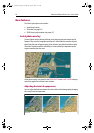
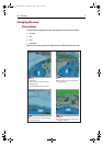
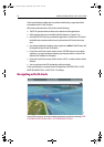
Active motion mode
This is the default mode when you open the 3D application provided that there is a
valid fix. The screen shows an aerial view of the 3D chart as if you are above your boat,
slightly behind it and looking forward (eye point). You can also view the chart from
different positions relative to your boat - see “View options” on page 17. As your boat
moves forward the chart automatically updates and reveals the changing view ahead.
In active motion mode you can adjust the pitch when ADJUST ON is set to CENTER, but
rotating or panning the chart will put it into planning mode.
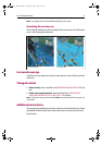
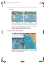
Planning mode
Planning mode enables you to view an area of the chart, different to the one in which
you are navigating.
To enter planning mode, just use the trackpad to pan to the area of the chart that you
want to view or turn the rotary control. This may require you to change the rotation of
the chart or change the range, making it easier to see a particular location.
All of the functions that are available in active motion mode can be used in planning
mode. Control of the chart is the same as working in active motion mode. However,
you will see that mode information in the status bar is shown in brackets to indicate
that you are in planning mode.
Pressing the FIND SHIP soft key will return the chart to active motion mode, showing
the chart in the forward looking view at your current position.
81259_1_NGC.book Page 16 Wednesday, July 27, 2005 11:51 AM