


10 Navionics Platinum Chart Card - User’s Guide
New features
The Chart Layers option now includes:
• Aerial photo overlay.
• 3D locator (see
page 21
).
• 2D/3D chart synchronization (see
page 21
).
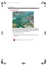
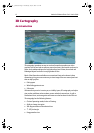
Aerial photo overlay
The aerial photo overlay feature will help you to interpret your environment and its
features. They cover the navigable waters up to 3 miles inside the coastline. Beyond
these limits the land will appear green (color charts) or grey (black and white charts).
The level of resolution and the availability of a colored overlay is dependent on the
region covered by the chart card.
Aerial photo overlay is accessed via the PRESENTATION and CHART LAYERS soft keys
and can be applied to individual chart windows.
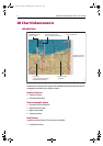
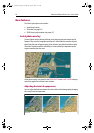
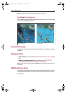
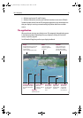
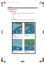
Adjusting the level of opaqueness
You can adjust the balance between the chart and the aerial photograph by changing
the overlay’s level of opaqueness.
D7923_1
D7920_1
20% level40% level70% level
Examples:
81259_1_NGC.book Page 10 Wednesday, July 27, 2005 11:51 AM