


2D Chart Enhancements 11
Note:
Any changes that you make will affect all displays in your system.
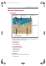
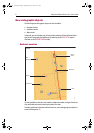
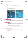
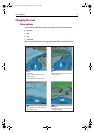
Specifying the overlay area
You can specify whether the overlay is displayed for land areas only or for land and sea
areas, via the Cartography Setup menu.
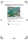
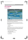
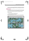
Increased coverage
In addition to coastal regions, the Platinum chart card also covers US lakes and inland
waterways.
Changed control
• Radar Overlay - Now controlled via the PRESENTATION and CHART LAYERS soft
keys.
• Radar/chart synchronization - Now controlled via the PRESENTATION -
CHART MODE & ORIENTATION - CHART SYNC - RDR soft keys.
Note:
The 2D chart can be synchronised with either the radar or the 3D chart (see page 21),
but not both.
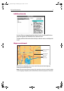
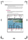
Additional menu items
The Cartography Setup Menu now includes controls to switch Business Services, Roads
and Additional Wrecks on/off, and to select either land or land and sea for the Aerial
Photo Overlay.
D7921_1
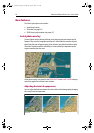
Land only overlayLand and sea overlay
81259_1_NGC.book Page 11 Wednesday, July 27, 2005 11:51 AM