


Introduction 3
Introduction
This User’s Guide introduces the Navionics Platinum chart card. Used in conjunction
with your Raymarine display, you will be able to access new and enhanced features
that will give you an accurate, easy-to-view image of the area around your boat.
Operation of the charts and their features is similar to the way in which existing chart
cards are operated. For full details please refer to the relevant display handbook.
Note:
The range at which these features appear may vary between display types and sizes.
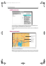
2D cartography
The Platinum chart card enhances many of the conventional 2D cartographic features
and introduces several new ones.
Enhanced features
• Additional business services information e.g. local restaurants, shops etc.
• Additional wrecks data for new wrecks.
• Major coastal roads.
• US inland waterways.
New features
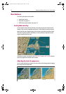
• Panoramic photos for many of the ports and marinas on the chart.
• Pilot book information for many ports.
• Aerial photo overlay of land and coastal waters.
• 2D and 3D (new application) synchronization.
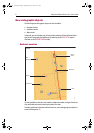
• 3D locator indicating the area covered by the 3D view.
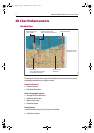
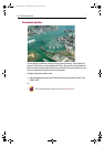
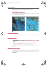
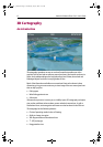
3D bathymetric charts
Navionics Platinum introduces the new 3D chart application. This provides you with a
three dimensional graphical view of land and sea contours around your boat.
3D cartography has the following features:
• Choice of operating modes, Active or Planning.
• Change of view point.
• 360
o
degree rotation of the selected view.
• Vertically exaggerate the view.
• Ability to indicate the area which your fishfinder transducer cone covers (if fitted).
To obtain the best results from thisapplication you should make sure that your display
is receiving accurate heading and position data from a suitable source.
81259_1_NGC.book Page 3 Wednesday, July 27, 2005 11:51 AM