


3Tracker500/500i User Manual
1.0 Tracker500/500i Introduction
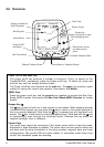
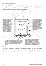
Congratulations on purchasing a Navman Tracker500/500i track plotter. The Tracker500/
500i is a compact, ruggedly built, highly integrated navigation instrument that has been
designed for ease of use. With this instrument you will be able to display your boat’s
position, track and destination. Complex navigation functions can be performed with a few
simple key presses, taking the hard work out of navigation. Tracker500i owners have the
option of using the integrated fuel computer to keep track of their boat’s fuel usage. The fuel
computer is suitable for all petrol engine boats, either inboard or outboard, and single or
twin engine. Fuel transducers must be purchased separately.
1.1 The Global Positioning System (GPS)
The GPS constellation comprises 24 satellites orbiting the earth, providing a worldwide
system for determining position. From any one point on the earth’s surface up to 12
satellites are “visible” to the GPS receiver. The positions of these satellites are constantly
changing. The Tracker500/500i antenna tracks all visible satellites simultaneously and
selects four or more satellites that produce the optimum geometry and signal quality for
determining an accurate value of the boat’s latitude and longitude. The superior
performance achieved with the Tracker500/500i 12 channel receiver provides increased
accuracy and reduced Time to First Fix (TTFF).
Note: The USA Department of Defence introduces a varying offset,
known as Selective Availability (SA), to degrade the accuracy of the
civilian GPS signal. As an approximate guideline it is generally
assumed that the accuracy obtained with SA active causes the GPS
derived position to be within 100 metres of the true position 90% of the
time and within 50 metres of the true position 50% of the time. On brief
occasions the SA can cause the position error to exceed 300 metres.
The constantly varying SA offset causes small errors in the indicated
boat speed and heading that may be noticeable at speeds of 5 knots or
less. The position, speed and heading errors have been deliberately
designed into the system and affect all GPS receivers in the same way.
They can be eliminated by connecting a differential (DGPS) receiver to
the Tracker500/500i. This receives corrections from a fixed base
station that is able to measure the introduced SA offset.
In times of military conflict, the USA Department of Defence has been
known to turn the civilian GPS signal off. This is an extremely rare
event, but should be guarded against by always having a secondary
means of navigation to fall back on. The warning screen that appears
each time the Tracker500/500i is turned on has a reminder to this effect.
1.2 Commonly Used Terms
Waypoints Positions such as fishing spots, favourite anchorages, dive locations and trip
destinations can be saved in the Tracker500/500i memory. These are referred
to as waypoints. Up to 500 waypoints can be stored in memory. The Tracker500/
500i will automatically allocate a name to a waypoint or the user can specify a
name. Waypoints are created by saving the boat position, saving the screen
cursor position or by entering the latitude and longitude of a location.
Marks Marks are temporary waypoints. They are created by a single press of the power
on/off key. Marks can be created at any time, regardless of the screen currently