


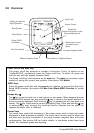
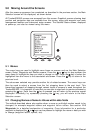
Tracker500/500i User Manual14
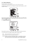
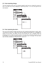
8.0 Highway Screen
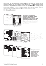
This screen provides a graphic ‘highway’ that shows your movement relative to your desired
course. The highway is drawn from your original start point to a selected destination point.
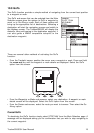
In the Highway screen the destination is positioned at the top of the display and the boat
position is automatically maintained in the central area of the display. A bird’s-eye view of
the highway is displayed on the screen. This provides a simple and effective method of
seeing exactly where you are in relation to your intended course. The width of the highway
can be set to between 0.1 and 5.0 miles or kilometres. The larger widths are mostly of
interest to sailors who may have to tack up wind towards a waypoint.
Note: With no destination (waypoint) selected, this page is of limited use.
The current speed and heading will be displayed on the lower section of
the screen, but the remainder of the page will be inactive.
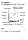
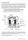
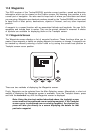
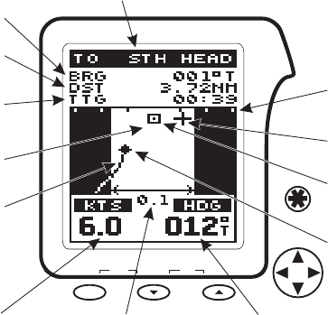
The following diagram shows the information available on the Highway screen.
Destination
Waypoint Name
Bearing to
Waypoint
Heading Marker
(Steering Indicator)
Destination
Waypoint Marker
10° Markers
Distance to
Waypoint
Current Boat
Direction or Heading
Boat Speed Width of
Highway
Graphic
Highway
Estimated Travel
Time to Waypoint
Current Boat Position
Relative to Intended
Course
Previous
Track
zoom-outzoom-in
mark
ctr
MOB
on
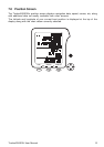
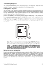
Your present position relative to your intended course is shown by the diamond in the centre
of the highway. Your present heading, relative to the current direction to the waypoint, is
indicated by the cross that slides along the horizon, while the destination waypoint is
represented by the stationary box in the centre of the horizon.
If you deviate by more than 30° either side of the waypoint, the heading marker will remain
hard against the edge of the screen.