


83
Map Data
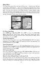
The Map Data menu lets you turn off the map — which turns the map
screen into a GPS plotter — turn on or off pop-up map info boxes, draw
map boundaries or boxes around areas of detail and fill land areas with
gray. You can also turn on or off Map Overlays, which display range
rings and latitude and longitude grid lines on the map. Navionics maps
also may be accessed on the Map Data menu. For detailed instructions,
see the Navionics Charts entry in this section.
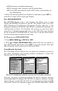
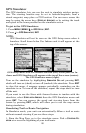
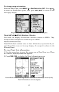
Map Menu (left) with Map Data Menu (right).
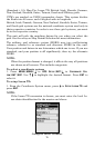
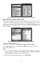
To Show Map Data
Press
MENU|↓ to MAP DATA|ENT. Press ENT to access the EARTH MAP
DETAIL selection list. From there, choose how much detail you want,
ranging from Off (so the unit operates like a GPS plotter) to High. After
the option is set, press
EXIT.
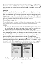
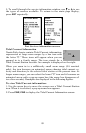
Popup Information
From the Map Data menu, press ↓ to
POPUP INFORMATION. With the option
highlighted, press
ENT to turn it on (check) or turn it off (uncheck). Af-
ter the option is set, press
EXIT.
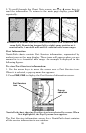
Draw Boundaries
From the Map Data menu, press ↓ to
DRAW BOUNDARIES. With the option
highlighted, press
ENT to turn it on (check) or turn it off (uncheck). Af-
ter the option is set, press
EXIT.
Fill Land with Gray
From the Map Data menu, press ↓ to
FILL LAND WITH GRAY. With the op-
tion highlighted, press
ENT to turn it on (check) or turn it off (uncheck).
After the option is set, press
EXIT.
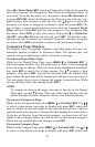
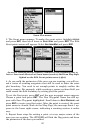
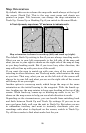
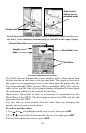
Map Overlays (Range Rings, Lat/Long Grid)
The map screen can be customized with range rings and/or grids that
divide the plotter into equal segments of latitude and longitude. Range
rings are handy for estimating distances on the map. Ring diameters