


80
GPS Simulator
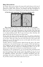
The GPS simulator lets you use the unit to simulate outdoor naviga-
tion. The starting location may be set in latitude/longitude, from a
stored waypoint, map place or POI location. You can move across the
map by using the arrow keys (
STEER W/ ARROWS) or by setting the track
and speed in the boxes provided on the simulator screen.
To get to the GPS Simulator:
1. Press
MENU|MENU|↓ to GPS SETUP|ENT.
2. Press ↓ to
GPS SIMULATOR|ENT.
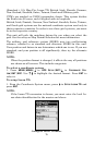
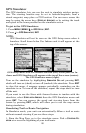
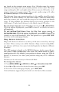
NOTE:
GPS Simulator will not be seen on the GPS Setup menu when it
launches. Scroll down below Use Indoors and it will appear at the
top of the screen.
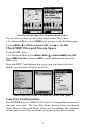
GPS Setup Menu with Use Indoors selected (left). Scroll past Use In-
doors and GPS Simulator will appear at the top of the screen (center).
The GPS Simulator menu (right).
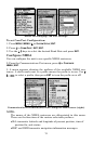
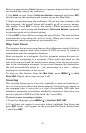
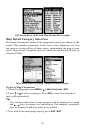
Turn on the simulator by highlighting SIMULATOR ON and pressing ENT,
which will turn on (check) or turn off (uncheck) the simulator. Press
EXIT
to close this menu. A message appears periodically, reminding you the
simulator is on. To turn off the simulator, repeat the steps above or turn
off the unit.
If you want to use the Steer with Arrows feature in tandem with the
simulator, select
STEER WITH ARROWS from the GPS Simulator menu and
press
ENT. You can remove the speed and steering boxes from the
screen by pressing
EXIT, which will allow you to use the map cursor
during simulation.
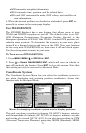
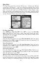
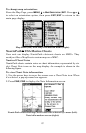
Simulating Trail or Route Navigation
In Simulator mode, your unit can automatically follow a trail or route
without manual steering if you use these steps:
1. From the Map Page, go to the simulator menu. Pick a
STARTING PO-
SITION
at or near the beginning of your trail/route.