


18
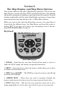
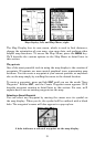
Using the map is as simple as turning on the iWAY. A screen similar to
those in the following images appears. For illustrative purposes, we have
removed the textual data boxes that usually appear at the bottom of the
screen, allowing more of the map to show. You can add or remove data
boxes using the Customize command on the Map Menu, described later in
this section.
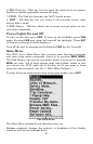
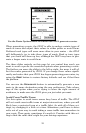
The arrow flashing in the center of the screen is your present position. It
points in the direction you're traveling. (Remember, a flashing question
mark on the arrow symbol or flashing text displays means the iWAY has
not yet calculated a position.)
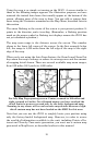
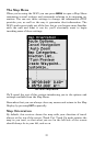
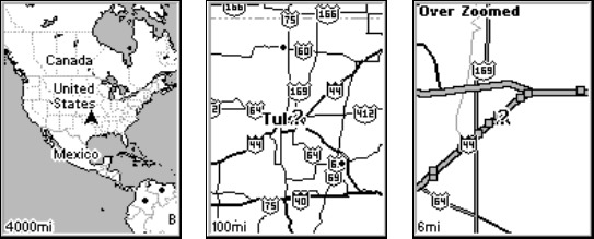
The map zoom range is the distance across the screen. This number
shows in the lower left corner of the screen. In the first example below
left, the range is 4,000 miles from the left edge of the map to the right
edge of the map.
When you're not using the Auto Zoom feature, the Zoom In and Zoom Out
keys zoom the map to enlarge or reduce its coverage area and the amount
of mapping detail shown. There are several available map zoom ranges,
from 0.02 miles (35.2 yards) to 4,000 miles.
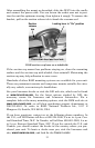
Far left, Map Page opening screen. Center, zoomed to 100 miles and
right, zoomed to 6 miles. Over Zoomed means you have reached the
detail limits in an area covered only by the basic background map.
Zooming in any closer will reveal no more map details because a high-
detail custom map has not been loaded on the MMC for this area.
Note that you can use the iWAY to roughly locate your position using
only the factory-loaded background map. However, in order to access
the wealth of information available to the unit, including Points of In-
terest and Turn-by-Turn route generation, you must use a custom map
generated in MapCreate, as described earlier in this manual.