


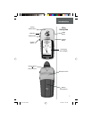
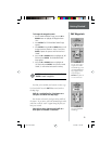

11
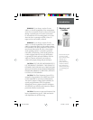
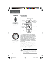
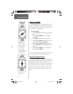
The Map Page showing
different symbols and
waypoints.
On the Map Page, the
UP and DOWN Buttons
are used to adjust the
map scale from 200 feet
to 800 miles.
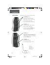
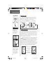
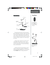
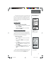
Map Page Basics
The Map Page shows where you are (the animated
fi gure) and provides a real picture of where you are going.
As you travel (the animated fi gure “walks”) and leaves a
“trail” (track log). Waypoint names and symbols are also
shown on the map. We will show you how to record your
location by marking a waypoint in the “discovering the
fun” section.
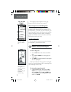
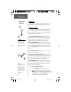
To help you better visualize the “real world”, eTrex
automatically rotates the map as you move, so that
waypoints that are ahead of you are always displayed in
front of the animated fi gure. The North Pointer always
shows you where north is.
To make sure you can see your entire trip, you can
change the map scale (from 200 feet to 800 miles!) by
pressing and holding the UP Button to view a larger area,
and the DOWN Button for viewing a smaller area.
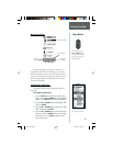
The Map Page
“You”; Your
Location
North Pointer
Path to
Destination
Destination
Waypoint
Map
Scale
“Trail” (track
log)
Getting Started
Page Basics
etrex manual.indd 10/12/00, 11:16 AM11