


ii GPSMAP
®
400 Series Owner’s Manual
IntroductIon
table of contents
Introduction ...........................................................................i
Tips and Shortcuts ................................................................... i
Manual Conventions ................................................................ i
Quick Links ............................................................................... i
Warnings ................................................................................. iv
Important Information ............................................................ iv
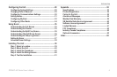
Getting Started .....................................................................1
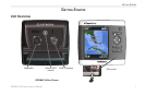
Unit Overview .......................................................................... 1
Turning the Unit On or Off ...................................................... 2
Adjusting the Backlight .......................................................... 2
Using the Keypad .................................................................... 3
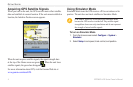
Acquiring GPS Satellite Signals ............................................ 4
Using Simulator Mode ............................................................ 4
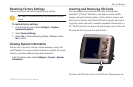
Restoring Factory Settings .................................................... 5
Viewing System Information .................................................. 5
Inserting and Removing SD Cards ........................................ 5
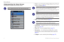
Understanding the Home Screen ........................................... 6
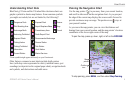
Using Charts ........................................................................7
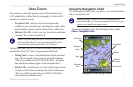
Using the Navigation Chart .................................................... 7
Using BlueChart g2 Vision ................................................... 11
Using Mariner’s Eye 3D ........................................................ 12
Using Fish Eye 3D ................................................................. 13
Using Fishing Charts ............................................................ 13
Enabling High Resolution Satellite Imagery ....................... 14
Viewing Aerial Photos ........................................................... 15
Viewing Current Station Information ................................... 16
Detailed Road and POI Data ................................................. 16
Using Automatic Guidance ................................................... 16
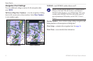
Changing the Chart Settings ................................................ 16
Using the Chart/Sonar Screen ............................................. 18
Where To? ..........................................................................19
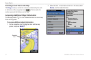
Navigating to a Destination .................................................. 19
Creating and Using Waypoints ............................................ 21
Creating and Using Routes .................................................. 23
Viewing Information ..........................................................25
Viewing Numbers .................................................................. 25
Viewing Tide Station Information ......................................... 26
Viewing Current Information ................................................ 26
Viewing Celestial Information .............................................. 27
Viewing User Data ................................................................. 27
Viewing Other Boats ............................................................. 28