


12 GPSMAP
®
400 Series Owner’s Manual
uSInG chartS
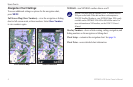
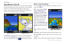
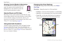
Using Mariner’s Eye 3D
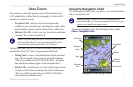
Mariner’s Eye 3D provides a bird’s eye view from above and behind
the boat (according to your course), and provides a visual navigation
aid. This view is helpful when navigating tricky shoals, reefs,
bridges,orchannels,andisbenecialwhentryingtoidentifyentry
and exit routes in unfamiliar harbors or anchorages.
Mariner's Eye 3D Navigation Chart
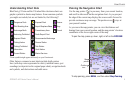
The RANGE (+) key moves the view closer to your boat and lower to
the water, while the RANGE (-) key moves the view away from the
boat. This is indicated by the scale ( )
at the bottom of the screen.
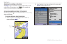
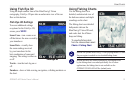
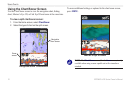
Mariner’s Eye 3D Settings
To access additional settings or options from the Mariner’s Eye 3D
screen, press MENU.
Colors—choose between Normal
(Default), Water Hazard, and
All Hazard. The Normal setting
highlights the land as you would
see it from the water. The Hazard
settings indicates shallow water
and land with a color scale. Blue
indicates deep water, yellow is
shallow water, and red is very
shallow. The Water Hazard setting
indicates land in green, and the All
Hazard setting shows land as dark
red.
Rings—toggle the range rings on
or off.
Safe Depth—adjust the depth at which red indicates shallow water.
Nav Lane Width—adjust the width of the course line drawn when
navigating.
Numbers—showorhidecruising,navigation,shing,andsailingnumbers.
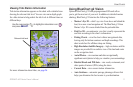
Mariner’s Eye 3D
(Water Hazard Colors)
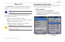
Mariner’s Eye 3D
(Water Hazard Colors)