


3-5
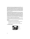
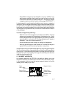
The CDI Page may be displayed by pressing the NAV key. This page
displays virtually all the information you need to guide your craft.
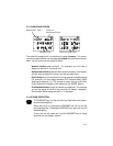
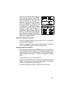
The CDI (Course Deviation Indicator) is oriented so that the center represents
your desired course and the CDI hash represents your position. You must
steer toward the center of the CDI to eliminate cross track error and stay on
course. The to/from arrow in the center of the CDI indicates if you are
navigating to the waypoint (up arrow) or if you have passed the waypoint
(down arrow). You may set the CDI alarm and CDI scale from the Setup
Pages (see Sections 4.3 and 4.7).
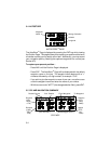
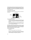
You may select the type of information you wish to see on each line. To make
a change, place the cursor under the field and press the MORE key until the
appropriate information is displayed. (See Appendix B for an illustration and
further explanation of the selectable navigation information on lines two and
three.)
On line one, you may elect to display a CDI or the active leg (see Chapter 6).
On line two, you may select one of three direction options (desired track,
bearing, or course to steer). You may also select one of three distance
options (steer direction and distance, range, or distance made good).
On line three, you may select one of three direction options (course made
good, track, or turn instruction). You may also select estimated time enroute
or one of two velocity options (ground speed or velocity made good).
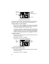
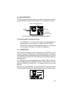
During the process of acquiring satellites, the GPS 50 will not provide
navigation data. The CDI Page will indicate this condition by displaying “NO
POSN” on line 1 and all navigation data on lines 2 and 3 will be blank. If the
GPS 50 is not navigating to a waypoint, the CDI will indicate this condition by
displaying “NO ACT WP” (no active waypoint) and all navigation data except
speed and track will be blank.
3.6 WAYPOINTS
The GPS 50 allows you to create, store, and use 250 alphanumeric
waypoints. A waypoint consists of a name (up to four letters or numbers), and
its latitude/longitude location. You will have the opportunity to use waypoints
extensively while operating the GPS 50. For example, you can navigate to
a waypoint, build a route using waypoints, and perform trip planning using
waypoints.