


3-3
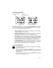
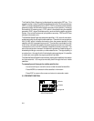
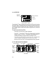
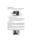
The Position Page may be displayed by pressing the NAV key. This page
displays your latitude and longitude relative to the selected earth datum (see
Section 4.11), as well as the altitude above mean sea level (MSL).
When the GPS 50 is performing 2D navigation, the last known altitude will be
used in the latitude/longitude computation. If the altitude is not accurate
within a few hundred feet, you should manually enter your altitude.
To change the altitude...
· Use an arrow key to move the cursor under the altitude.
· Enter the altitude. If your antenna is mounted on a high mast, make
sure you add the mast height. (Remember to complete the data entry
by pressing ENT.)
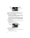
During initial satellite acquisition, the displayed position is the last computed
position stored in the GPS 50. If your position has moved more than 1000
nautical miles with the power off, you may wish to enter a more accurate initial
position to speed up the acquisition process. (You may also change the
position at any time when you are operating in simulator mode.)
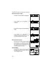
To change the latitude/longitude...
· Use an arrow key to place the cursor under the latitude field.
· Check the hemispheric designation (“N” or “S”) of the latitude. If it is
correct, go to the next step. If it is incorrect, press the CLR key until
the correct hemispheric designation is displayed.
· Enter the latitude (remember to complete the data entry by pressing
ENT).
· Check the hemispheric designation (“E” or “W”) of the longitude. If it
is correct, go to the next step. If it is incorrect, press the CLR key until
the correct hemispheric designation is displayed.
· Enter the longitude (remember to complete the data entry by pressing
ENT).