


3-1
CHAPTER 3
BASIC OPERATION
3.1 POWER ON
After you turn your GPS 50 on, it will conduct a series of self tests and display
the following notices: “VER x.xx”, “COPYRIGHT”, “1991-1992”, and
“GARMIN”. Following completion of the tests, the GPS 50 will begin
acquiring satellites that will typically take two minutes to obtain a position fix.
Initially, the GPS 50 will display the “ACQ” banner; it will inform you when a
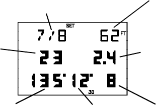
position fix is obtained by transitioning to either the “2D” or “3D” banner.
When four or more satellites with good geometry are available, the GPS 50
will automatically operate in the 3D mode in which latitude, longitude, and
altitude are computed. If only three satellites are available, the unit will
operate in 2D mode in which only latitude and longitude are computed. When
operating in the 2D mode, the unit will use the last computed altitude or your
last entered altitude (Section 3.3 describes how you may enter the altitude).
If less than three satellites with acceptable geometry are available, the “DR”
banner will be displayed.
Your GPS 50 will automatically update satellite orbital data as it operates. If
you have not operated your unit for a period of six months or longer, it will take
approximately 12.5 minutes to search the sky and collect new orbital data.
You will be informed when your unit is searching the sky with the message
“SRCH SKY”. Additionally, the “DATA” banner will be displayed. Once
satellite orbital data is collected, it will be stored in battery backed up memory.
This means the data will not be lost when you turn your GPS 50 off.
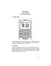
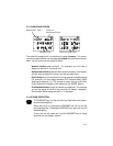
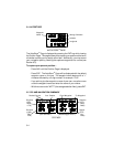
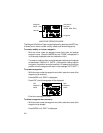
3.2 SATELLITE STATUS
Satellites EPE
Tracked/Visible
Satellite DOP
Identifier
Azimuth Elevation Signal Quality
SATELLITE STATUS PAGE