


The map setup page also allows you to control whether or not the various way-
point types and the identifiers for these waypoints are displayed. Settings for each
waypoint type allow you to select the maximum scale at which that feature should be
displayed, or you may turn that waypoint type off for all scales. For example, by set-
ting ‘VOR’ at 80, VOR waypoints will appear on the map display at all scales from 80
on down, but not at 120, 200 or 300.
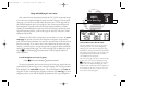
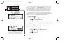
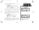
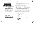
To display airports, navaids and/or user waypoints:
1. Press and hold
M
, then rotate
O
to display the ‘MAP Setup’ page.
2. Press
C
twice and rotate
O
to highlight ‘apt’, ‘vor’, ‘ndb’, ‘int’ or ‘user’.
3. Rotate
K
to select the maximum map scale for that waypoint type, or select ‘off’ to dis-
able the waypoint type entirely.
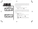
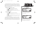
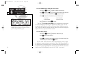
To display waypoint identifiers:
1. Press and hold
M
, then rotate
O
to display the ‘MAP Setup’ page.
2. Press
C
twice and rotate
O
to highlight ‘apt ident’, ‘vor ident’, ‘ndb ident’, ‘int ident’,
or ‘user ident’.
3. Rotate
K
to select the maximum map scale for that waypoint category, or select ‘off’ to
disable the waypoint identifiers.
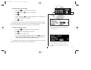
The boundaries for airspaces that appear on the map display may be enabled or
disabled by airspace type. As described above for waypoints, you select the maxi-
mum scale at which the airspace should appear or turn the airspace type off entirely.
Airspace categories for Class B/CTA, Class C/TMA, MOA, restricted and other SUAs
are provided. ‘Other sua’ includes alert, caution, danger, training and warning areas.
77
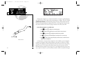
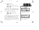
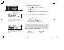
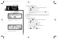
A scale setting of ‘200’ for airports will display
airport locations on the map display for all scales
from ‘200’ on down. Airports will not appear on
the map display at a scale setting of ‘300’.
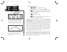
The automatic zoom feature will automatically
adjust the map display through progressively
lower scale settings as you approach your
destination waypoint.
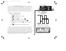
SECTION
6
UNIT SETTINGS
Map Page Setup
250xl manual 2 7/17/98 1:33 PM Page 77