


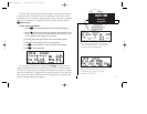
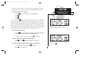
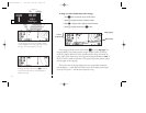

The following functions may be displayed in the ground speed field:
• gs— Your present speed over the ground.
• str— Steer direction and distance, or digital crosstrack error. An ‘L’ or ‘R’
indicates which direction to steer, while the distance value indi-
cates how far you are off course.
The following functions may be displayed in the distance field:
• dis— Distance from present position to the ‘active to’ waypoint.
• str— Steer direction and distance, or digital crosstrack error. An ‘L’ or ‘R’
indicates which direction to steer, while the distance value indi-
cates how far you are off course.
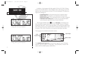
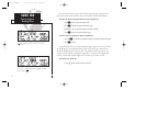
The following steering functions may be displayed in the direction field:
• brg— Bearing, the direction from your present position to the waypoint.
• cts— Course to steer to reduce cross track error and re-intercept course.
• dtk— Desired track, the course between the active from and to waypoints.
• trk— Track, the direction of movement relative to the ground.
• trn— Turn, the direction and degrees to turn to get back on course.
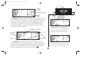
The following information can be displayed in the time field:
• eta— Estimated Time of Arrival (at the active to waypoint).
• ete— Estimated Time Enroute (to the active to waypoint).
• trk— Track, or the direction of movement relative to the ground.
• vn— Vertical Navigation, or VNAV. If VNAV has been activated, this field
indicates either the elapsed time before the VNAV maneuver is to
begin or the VNAV altitude (the suggested altitude you should be fly-
ing in order to complete the maneuver).
13
SECTION
1
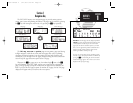
NAV KEY
Configuring the
CDI Page
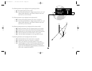
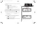
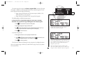
WPT 1
S
T
R
L
NORTH
NORTH
WPT 2
BRG
TRK
G
S
DIS
A
IR
P
L
A
N
E
D
T
K
250xl manual 2 7/17/98 1:26 PM Page 13