


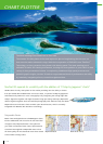

On top of the cartography, you can save the following marks and points in the
NavNet 3D internal memory:
▲
Up to 10,000 ship’s track points;
▲
Up to 2,000 points and
▲
200 planned routes, within which up to 100 waypoints can be placed.
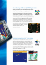
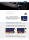
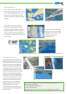
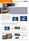
Satellite PhotoFusion
TM
Satellite photography is included in the
Mapmedia Raster and Vector charts, and
Satellite PhotoFusion
TM
with the charts is
a feature available only with FURUNO’s
NavNet 3D. Land areas (zero depth) are
completely opaque, so that these areas
are displayed as satellite photos on the
chart. As the depth increases, the satellite
image is merged with the chart data to
provide you, the user, with added detail
on seabed areas in shallow water without
losing vital chart information. In deeper
water where the satellite image has no
detail to offer, the chart is displayed
without alteration. This ensures that
navigational integrity is not only
maintained but also enhanced where it is
most needed in areas where grounding
might be a risk.
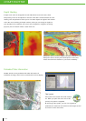
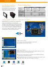
NOAA Vector + Satellite PhotoFusion
TM
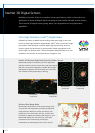
Mapmedia NOAA Vector
Mapmedia Vector
Vector charts contain a huge volume of
information in different layers, each of which
can be selectively displayed. As you zoom
into the chart, increasing levels of detail
can be seen without any sacrice in image
resolution.
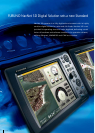
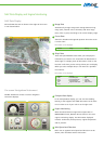
NavNet 3D now offers three different
sources of vector chart options with the
addition of C-Map by Jeppesen*. Optional
"C-Map by Jeppesen" vector cartography*
delivers a wealth of important chart detail
for navigation, including spot soundings and
depth contours.
C-Map by Jeppesen 3D Vector + Satellite PhotoFusion
TM
Mapmedia C-Map by Jeppesen 2D Vector
*A software update (v2.05) will be
necessary to use the new “C-Map
by Jeppesen” charts, which will be
available for download at
www.NavNet.com.