


17-18
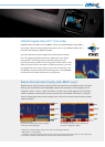
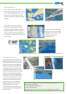
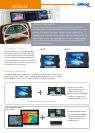
Radar-Chart overlay
Mapmedia Rastar
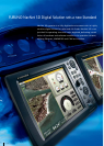
NavNet 3D is the only chart plotter on the market providing users the ability to choose
from pre-loaded ofcial NOAA raster and vector charts, or optional "C-Map by Jeppesen"*
and "Datacore by Navionics" vector cartography. Fully integrating the cutting-edge data
analytic algorithm together with high-resolution image processing technique, Mapmedia
delivers digital navigation charts and satellite photography with absolute clarity and detail.
Mapmedia vector and raster charts are built upon 3D architecture, which is smoothly
integrated with NavNet 3D’s TimeZero
TM
technology.
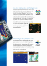
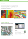
Mapmedia Raster
Raster charts are digitized scans of NOAA paper charts.
For the traditionalist who is used to the touch and feel
of a paper chart, Mapmedia raster is the option for
you. Unlike conventional raster charts, high-resolution
scans have been applied to Mapmedia raster so that
the chart quality will not deteriorate even when viewed
at the smallest of range scales.
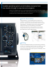
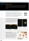
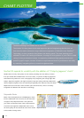
The Most Amazing Chart Plotter You’ve Ever Seen
The NavNet 3D chart plotter is the most impressive piece of engineering that has ever set
foot onto the marine electronics stage. With the incorporation of FURUNO’s new TimeZero
TM
Technology, we have created a chart plotter with blazing speed. The most amazing part is
utilization of native 3D charting architecture, showing the exact position of your craft in a wide
variety of chart presentation formats. Incorporating a dedicated high-speed processor and
powerful graphic engine, NavNet 3D delivers unprecedented levels of performance and utility
by seamlessly integrating diverse, essential navigational data.
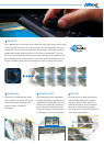
NavNet 3D expands its versatility with the addition of "C-Map by Jeppesen" charts*
CHART PLOTTER